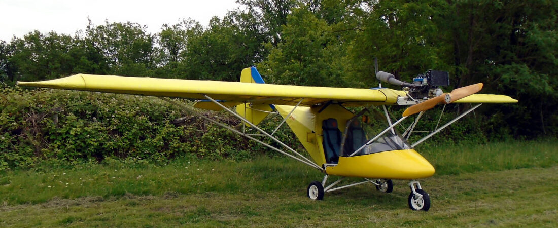
I didn’t have time to post about what had been going on since my last flight when I thought about getting MYRO to France as soon as there was a suitable weather window. Well, that happened as expected over the Easter week-end, just gone, and I did indeed succeed in flying MYRO over. A lot of planning went into it which was what took much of my time beforehand and the flight itself was an adventure that I’d never have missed for anything. I kept a mental record of the things that happened, the places I visited and the people I met. I wrote it down quickly while it was all still fresh on the microlight forum and have re-written it for here. It’s broken up into four parts, and here’s the first of them.
I left for France as planned on Good Friday, 6th April. My first stop, to close my flight plan and get official clearance into France was at Abbeville and I’d faxed the French ‘douane’ and police on the standard number with a copy to Abbeville airfield the day before departure. I’d then phoned Abbeville to check they’d got it and confirm my intended arrival time in advance because they are a non-radio airfield. The ‘Auto Info’ frequency in France is 123.50 and Abbeville uses that just like hundreds of other airfields in France. For anyone who’d like to know, all the stuff that’s needed is on the Abbeville airfield plate which can be found in English on the following link.
I then did my flight plan from Stoke to Abbeville and filed it for free on the EuroFPL web site at the link below.
I prefer the flight plan system on the EuroFPL web site to the UK NATS AFPEX one, which I’ve never tried personally, although many of my fellow members at Stoke report that they have had lots of problems with filing their plans on AFPEX for them only to be rejected later due to errors. The EuroFPL system however, allows you to create and store your flight plan for later submission, at which time it verifies it and shows it coloured red if it contains errors or green if it doesn’t. This saves time and stress because you can be assured that when you do click the ‘File Flight Plan’ button, it will go through. I was going to buy SkyDemon to do this for me along with all the other stuff it does but as I thought that once in France I’d probably have very little use for it, I decided not to. But I think it’s brilliant software and if I had a microlight that was capable of more extensive touring – which MYRO isn’t really 🙂 – I’d have had no hesitation in buying it as I’d originally planned. I found that even the SkyDemon 30 day trial version was a great help to me in my planning and I have to confess that I used its flight plan ‘screen printout’ which you can’t file in the 30 day version though, as the basis for the plan I put in on EuroFPL.
Then as usual, whenever you make time-sensitive plans, everything began to ever-so-slightly unravel. I was a bit late getting to Stoke, mainly because my car windscreen was frozen up, and when I arrived, because the overnight temperature had been something like -8 deg C, MYRO’s wings were covered with thick frost. Its wing covers were damaged in the 80mph winds we had in January and I haven’t finished repairing them yet, so even if I had been ready, I couldn’t have got away until all the frost had been removed. When everything had been sorted I was something like 45 minutes behind schedule. I knew I’d never be able to make that up on a 2 hour leg into Abbeville so I just had to swallow it.
The take off went fine and after saying cheerio to my pal Ken who’d dropped me off at Stoke over the radio, I switched to Farnborough East and called in. Nothing. OK, then I tried Manston. Again nothing. Then Lydd, Headcorn and back to Farnborough. Still nothing, so I assumed my radio had let me down for the first time ever. I decided there was no way I was going to go back and carried on flying through about 2500ft by that time for my planned 5000ft and then, when I tried Farnborough again they came through 5s. So that was a relief!
We went through the usual chat and my ‘negative transponder’ response didn’t seem to worry them too much. We kept in touch with occasional position reports but I suspect they could see me. I’d given them an estimate for Dover and some time later just I was overhead and about to coast out they called asking for my position.
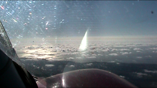
Unfortunately my plans to take loads of pics and videos during the flight were mostly scuppered by the weather. It was OK over the UK but taking shots through France was impossible because of turbulence and bumps the whole way down, and there was no way that I could relax for even a moment to get my camera out and aim it. And then there was the vis, but I’ll come on to that later. I did have the camcorder running after take off at Stoke though, and here’s a screenie I’ve captured off the video from when I was approaching Dover at about 5200ft.
What you can’t see from it is that it was CAVOK with absolutely no cloud in the UK which made me think I was going to get the flight of a lifetime. But what you can see is the broken low cloud starting at Dover with an ominously murky looking layer in the distance starting at the French coast, and this did help to make it the flight of a lifetime, but for a completely different reason however 🙂
I’d given Farnborough an estimate for the FIR boundary and as I crossed it I called to tell them I was changing to Lille. What I’d done as well the night before the flight was put all the frequencies that I was going to need into my trusty Vertex VXA-220 radio, more or less in the order I was going to need them and all also with alpha name tags. This made changing to the right frequencies when I needed to a complete doddle. Lille came in loud and clear and after getting my position and altitude they were keen to get me down to 1500ft or less by the French coast to ensure I stayed under their TMA. I knew that of course and after I did that and then advised them that I was going to avoid CAS until I arrived at Abbeville they were very happy and more or less left me alone apart from the occasional request for a position report. They also advised me that they had no known traffic or any other issues on my route to Abbeville so that was helpful. However, what I did have was a broken cloud base of 1500ft and quite severe turbulence. This wasn’t as bad as I’d experienced in the past though, so I wasn’t too worried. What I didn’t like much though was a visibility of about 3 miles or occasionally less and little did I know that this was going to be the best I’d get until I got to about 10 miles from my ultimate destination in the Dordogne!
Luckily I was quite well prepared. Visual navigation would have been a total non-starter, as I believe it is for any long solo flight over unknown terrain no matter what charts you may be carrying. So what I’d done was scan and load the charts I needed into MemoryMap and then print out a screen capture of each flight leg onto A4 paper. Then I’d sticky taped all the prints together in order, wrapped them around a sheet of thin A4 cardboard to stiffen them and popped them into a clear plastic folder secured with a small crocodile clip. So at any time I had two flight legs visible, one on the front and one on the back. Then after I’d flown them, I switched over to the next two legs and as I only had four (three on day one and one on day two), I only had to do it once, but in theory the method would work no matter how many legs a flight consisted of. So as the flight progressed, I could compare my position on my ‘cheap car satnav’ with my position on my ‘chart’ to work out my time estimates, and the result was that I was never more than a minute out on any leg, which I thought was pretty good. It also allowed me to accurately estimate my fuel burn and although it was a bit higher than I’d originally planned for, the safety margins that I’d built in always meant that I never had any worries on that score either. And it also meant that I didn’t have to have reams of actual French maps in the cabin with me, which was already extremely cramped, what with me, two jerries, as many of MYRO’s covers as I could fit in, my flight bag, my personal bag and, of course, my own fuel funnel (I’d never, ever use anyone else’s).
With my second tank I could load about 50 litres into MYRO. This, at 15 lit/hr would give me an endurance of about 3 hours and I’d planned for none of my legs to be quite as long as that. I’d also loaded two 20 litre jerry cans of pre-mixed 2-stroke so I’d planned my fuel stops to use the fuel in the tanks and then for that to be topped up from the jerries with more added when needed from local purchases. I’ve left my papers in MYRO back in the France now but as a rough idea, I didn’t need to buy fuel at Abbeville where there’s only very expensive AVGAS because I could fill my tanks back up from my jerries and fly on to my next stop at Le Gault St Denis near Chateaudun where I’d arranged to pick up more mogas. I’d also taken my own oil – just enough for the 40 additional litres of fuel that I thought I’d need to buy en-route.
—- Continued in Part 2 —-


